Emma Witanowski
Emma is receiving her Master of Urban Spatial Analytics ('25) from the University of Pennsylvania, where she has deepened her expertise in GIS and developed new skills in data science and advanced spatial analysis. While at Penn, she interned with Center City District (CCD) as a GIS Intern, contributing to data collection, spatial analysis, and visualization projects.
She received her undergraduate degrees from Villanova University, earning a Bachelor of Science in Environmental Science and a Bachelor of Arts in Geography, along with a minor in Studio Art ('24). Her academic foundation reflects a strong interdisciplinary approach that bridges environmental science, spatial thinking, and visual communication.
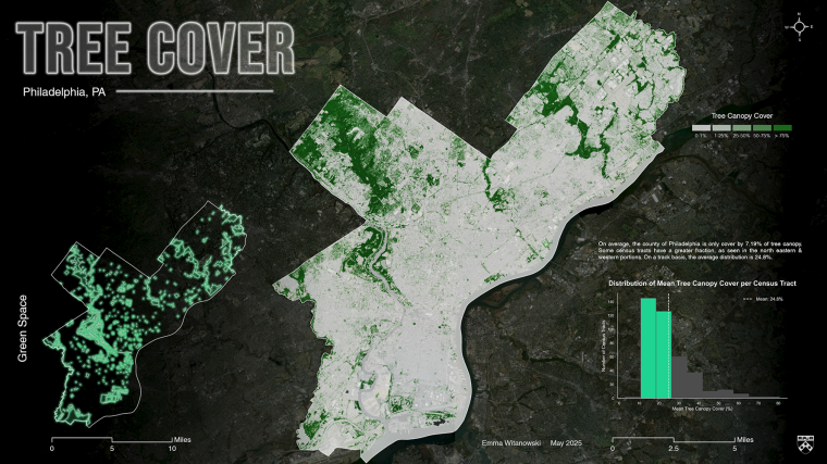
Emma’s research focuses on using GIS and remote sensing to address challenges in conservation, sustainable land development, and neighborhood change. She combines strong technical skills with a creative perspective rooted in her art background. Her emphasis on visual storytelling allows her to produce maps and graphics that make complex spatial information both accessible and compelling.
After graduation, she will pursue a PhD, where she plans to build on her technical training and environmental background to advance research at the intersection of geospatial technology, and climate change, and equitable development.
She received her undergraduate degrees from Villanova University, earning a Bachelor of Science in Environmental Science and a Bachelor of Arts in Geography, along with a minor in Studio Art ('24). Her academic foundation reflects a strong interdisciplinary approach that bridges environmental science, spatial thinking, and visual communication.
Emma’s research focuses on using GIS and remote sensing to address challenges in conservation, sustainable land development, and neighborhood change. She combines strong technical skills with a creative perspective rooted in her art background. Her emphasis on visual storytelling allows her to produce maps and graphics that make complex spatial information both accessible and compelling.
After graduation, she will pursue a PhD, where she plans to build on her technical training and environmental background to advance research at the intersection of geospatial technology, and climate change, and equitable development.