
 Expand Image

Character studies are a promising new model for historic resource surveys. The Character Study Project (CSP) is designed to address immediate practical needs as well as long-term strategic issues in the planning and preservation fields by (1) collecting and analyzing block-scale data about the historic urban environment, (2) integrating this data into existing planning and policy frameworks, and (3) completing survey work within tight timeframes and budgets.
Currently, no methodology exists in the professional preservation and planning fields for producing practical, plan-ready data about historic resources across large areas quickly and inexpensively. Traditional historic preservation surveys collect and analyze data building by building, a detailed method whose cost and time requirements can prohibit any survey work from happening-and result in reactive, ad hoc preservation efforts and plans that lack important data on the historic built environment.
The Character Study Project bridges this gap with a time- and cost-efficient way to collect data on built character and potential historic resources. Its innovative approach employs web-based aerial images, digitized historic maps, and GIS technology to quickly classify multi-parcel clusters by chronology and building typology, assemble and analyze the data, and field-check the digital survey to gauge integrity and ensure accuracy. The results can be easily integrated into planning systems and considered on an equal footing with other planning issues.
The CSP has three primary goals:
- To create citywide data on potential historic resources in Philadelphia that can be integrated with planning databases and inform public decision-making;
- To enable evidence-based prioritization of future preservation efforts by providing a baseline of information on the historical character of the built environment; and
- To develop a replicable, resource-efficient methodology that can be used in other towns, cities, and regions.
CSP work builds on the recent efforts of the Preservation Alliance of Greater Philadelphia, Philadelphia City Planning Commission, and Philadelphia Historical Commission to undertake comprehensive preservation planning for the entire city. The need for citywide data on historic resources, though long recognized, was made more urgent by initiation of the Philadelphia 2035 comprehensive plan process. Initiated by the Graduate Program in Historic Preservation at the University of Pennsylvania, the CSP was designed to input directly to the PCPC's District Planning process and to aid the Historical Commission and Preservation Alliance in regulating and advocating preservation matters in the context of the entire city. Character study data is envisioned as a direct contribution to the District Plans (documenting the historical evolution of the districts and identifying areas warranting preservation attention as well as areas with few historic resources) and a valuable input to strategic deployment of advocacy and documentation efforts by the entire preservation community.
Research drew from previous work in Philadelphia and incorporated best practices from American and international projects in Austin, Los Angeles, Norway, England, and others. A methodological framework was discussed with local partners from the City of Philadelphia and the preservation community, then expanded into a pilot study for local testing. The pilot was conducted in Philadelphia's Lower Northeast planning district in January 2012. It included classification, fieldwork, and analysis, and concluded in the incorporation of results into the Philadelphia Planning Commission's Lower Northeast District Plan. It successfully demonstrated character studies' efficacy, yielding focused, useful data in a short time period and producing an analysis of historic resource patterns over a complex six-square-mile district.
The next step envisioned for the CSP is implementing character studies for the rest of the city, in coordination with each of the 16 remaining District Plans and with the ongoing cooperation of the Planning Commission, Historical Commission, and Preservation Alliance; and conducting outreach about the methodology to other towns, cities, and regions.
For more information, contact Prof. Randall Mason at rfmason@design.upenn.edu.
Downloads

Methodology
The stages outlined here and illustrated in the attached graphic provide a flexible approach that can be adapted to many cities' unique landscapes and situations. A pilot study in Philadelphia in January 2012 tested and refined the methodology.
Fieldwork
Fieldwork develops a sense of local history and geography. Initially, it involves examining historic and current maps with attention to typical and unique development patterns and buildings. Surveyors meet with City planning and preservation staff to get a "quick and clean" orientation to the study area, including an overview of local history and areas and buildings of interest. Later Fieldwork stages include assessing selected properties for integrity in a windshield survey and field-checking boundaries of potential historic districts.
Research
In the Research stage, surveyors learn about the study area's historic context and classify current and historic maps to reveal the area's contemporary built character and its evolution. This stage draws extensively on digital tools (GIS and web) to allow coverage of a large area in a short time. It provides the basis for understanding major development eras and themes that manifest in the built environment.
Synthesis
This stage synthesizes data from research and fieldwork, tying geographical and historical development patterns to the contemporary built environment. In the Significance stage, surveyors examine the evolution of the current landscape, consider information from the Rapid Historic Context Statement, and set criteria for properties to be surveyed. Post-survey stages include Analysis, where potential historic resources are mapped, and Final Products.
Engagement
The Engagement stages acknowledge that public support is important to sustainable preservation and that community members have information about local resources that cannot otherwise be discovered in a character study's short timeline. General public participation is folded into area plan meetings to reach people not already involved with preservation and conserve resources. Other Engagement stages come at the end of the character study process, when character studies' final products are used to engage community members and City staff and develop broader public support for historic preservation.
Downloads
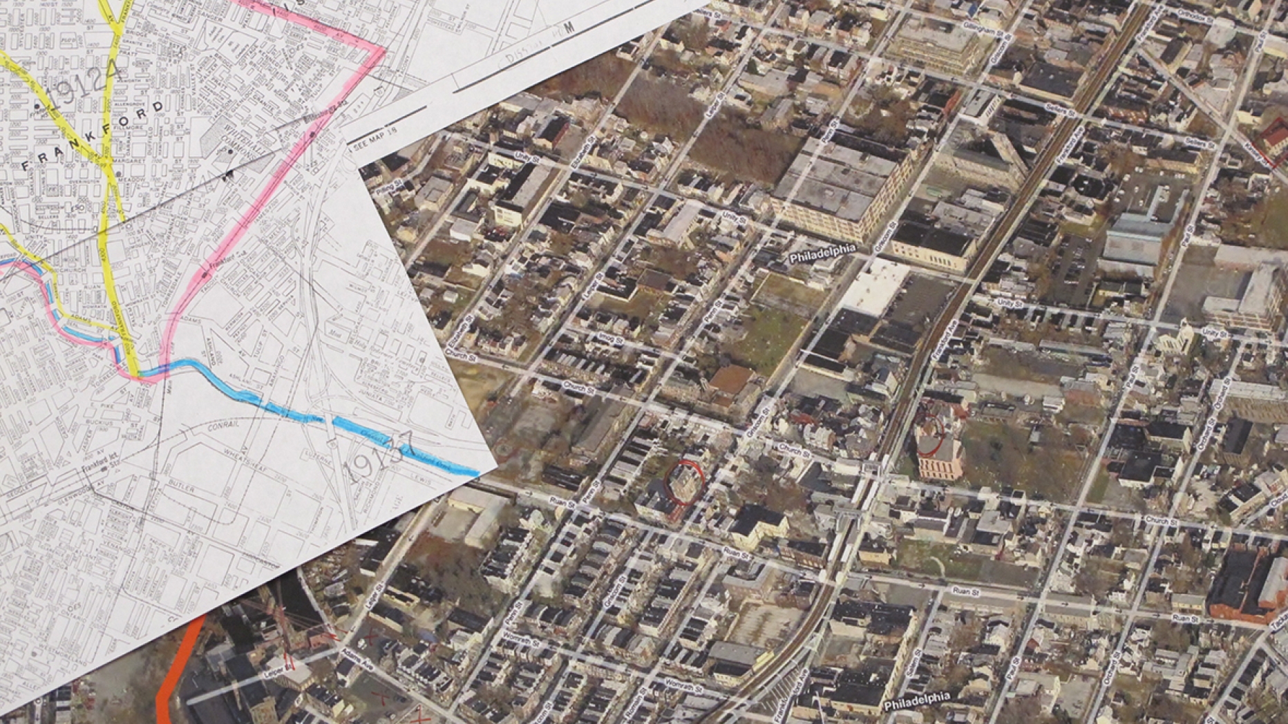
Pilot Study
A pilot study was conducted in Philadelphia's Lower Northeast planning district over five days in January 2012. The Lower Northeast occupies 5.9 square miles and has a varied history, with development spanning from the 17th century in Frankford to the mid-20th century above Roosevelt Boulevard.
The pilot successfully demonstrated character studies' ability to yield useful, accurate data about the built environment and potential historic resources in a short amount of time. The pilot methodology included first impressions, classification, significance, survey, and analysis. Its results will be incorporated into the Philadelphia Planning Commission's Lower Northeast District Plan.
Conclusions
Based on research, pilot survey results, and feedback from stakeholders in Philadelphia, character studies are a sound way to quickly gather data on large planning areas, with the flexibility to survey smaller neighborhood areas. Web-based classification allows fast, accurate classification of built character, and windshield surveys are an effective method for gauging integrity at the scale of multi-parcel groupings.
The methodology is not invincible. Some data may be missing; some resources will likely be misclassified. Yet field surveys and institutional and community knowledge reduce the risks of important information falling through the cracks, and the benefits of a character study significantly outweigh potential drawbacks.
Technically speaking, GIS provides a superb platform for character studies. It allows efficient collection of data for multiple attributes and has a powerful capacity for dynamic multivariate analysis. At the conclusion of a character study, it is possible to locate groupings of X typology that developed during Ytime period and have Z level of integrity. This type of quantitative knowledge at a multi-property, sub-block scale has the potential to be highly useful to planners and preservationists seeking specialized information, particularly when integrated with existing planning databases.
GIS also has the potential to support much more sophisticated analyses. For example, the data collected in the pilot study could be used in the following analyses:
- Analyzing where the oldest properties are located in relation to contemporary industrial, religious, and civic properties; historic streams; railroads and trade routes; and topography
- Examining whether proximity to major streets or the Market-Frankford El is correlated with integrity
- Identifying potential worker housing as housing located within a given radius from an industrial property that developed in the same interval
- Exploring the relationship of integrity and building age with other factors in the City database, such as property values, building and demolition permits, vacancy rates for nearby buildings and lots, and so forth; or block-level Census data