Stuart Weitzman School of Design
102 Meyerson Hall
210 South 34th Street
Philadelphia, PA 19104
Get the latest Weitzman news in your Inbox
 Expand Image

Media Contact
Michael Grant
mrgrant@design.upenn.edu
215.898.2539
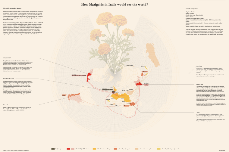
Richard Weller, Meyerson Chair of Urbanism, professor and chair of landscape architecture; Christopher Marcinkoski, associate professor of landscape architecture; and Javier Arpa, lecturer in landscape architecture, contributed articles to the latest issue of Domus magazine, which focuses on how cities must adapt to accomodate for a future made up of dramatic climate change, depletion of natural resources, huge income disparities, moving populations, and exponential population growth. Arpa and Marcinkoski's article explores urbanization in Africa, while Weller's takes on the threats to biodiversity from urbanization globally.
From “Africa in the Making: African Speculations,” by Javier Arpa and Christopher Marcinkoski
The research titled “African Speculations” explores the recent proliferation of speculative urbanization activities across the African continent. The investigation includes selections from a critical survey of more than 100 territorial-scale speculative urbanization projects proposed or undertaken throughout Africa since the height of most recent prior global real estate boom and bust in 2005. Each proposal, at more than 300 hectares in scale, shares a set of common characteristics that allow it to be defined as a “new town”. Yet beyond these similarities, the examples can be categorized under nine distinct urban typologies: new national capitals; technology/industry-driven cities; new financial centers (CBDs); middle-class housing estates; social or subsidized housing programs; tourist and entertainment enclaves; luxury housing estates; the occasional radical redevelopment of existing fabric; and what can be characterized as greenfield megacities.
A series of case studies have been chosen to offer a detailed explanation of each development typology.
Sample Typology: New National Capitals
No new town typology is more indicative of the political and economic belief in speculative urbanization than the New National Capital. At present, no fewer than six new capital cities are being planned or constructed on the African continent – in essence one out of every nine countries in Africa is building a new capital city. Like Canberra, Washington, D.C. and Brasília before them, these cities are intended to project what an individual country aspires to be, as much as what it represents today. In this way, the appearance of this typology makes clear the perceived correlation between global political and economic status, and the production of novel or iconic urban form.
The correlation between iconic urban form and a projection of political power is not new. What is unique, however, is the inversion of this relationship to the point where the physical construction of the constituent components of the “global city” are now believed to be an expedient means to an end, rather than a direct product of real, growing economic and political status.
Sample Case Study: Oyala, Equitorial Guinea
Oyala is a new purpose-built national capital located on the banks of the Wele River, deep in the rainforest of continental, oil-rich Equatorial Guinea. The multi-billion dollar project is meant to serve the needs of President Obiang to guard against further coups after a failed attempt in 2004. Before forests were cleared to give way to a new urban grid, the Djibloho Dam opened in 2012 to prevent flooding and secure hydroelectric power for the new city. A new highway connection to the port of Bata, and the new Mongomeyen Airport will facilitate the arrival of people and supplies, as all provisions need to be imported, from construction materials to food for the workers.
From “A New Beginning: Atlas for the End of the World,” by Richard Weller
Seen from 28,000 miles away, the earth is a beautiful blue sphere. But its beauty is deceptive. We don’t see the 5 billion tons of surplus carbon we pump into the atmosphere every year. We don’t see our toxic waterways, mountains of waste, gutted forests and sprawling megacities.
Within vast monocultures of cattle and grain, the trained eye can just make out an archipelago of green islands – so-called “protected areas” into which the world’s genetic biodiversity is now huddled.
The most important of these areas are known as biodiversity hotspots. The 36 “hotspots” are regions agreed upon by the scientific and conservation communities as the most important and the most threatened biological places on earth. Hotspots are to biology what libraries are to culture. They are also regions of exceptional linguistic diversity, much of which is also predicted to disappear by the century’s end – suggesting that the fate of nature and the fate of culture is one and the same. Not all, but many of the hotspots are also bedeviled by poverty, violence and corruption. They are also parts of the world that get very little attention from the global design community. The Atlas for the End of the World is an ongoing research project that focuses on land use and urbanization in these regions.
The world’s first atlas, the Theatrum Orbis Terrarum (“Theatre of the World”) was published in 1570 by the book collector and engraver from Antwerp, Abraham Ortelius. With his maps, Ortelius laid bare a world of healthy – we can now say “Holocene” – ecoregions ripe for colonization and exploitation. Lauded for its accuracy, the Theatrum quickly became a bestseller.
Despite its apocalyptic title, the Atlas for the End of the World is not about the end of the world per se; it is about the end of Ortelius’s world, the end of the modern world as a God-given and unlimited resource for human exploitation. On this, even the Catholic Church is now clear: “We have no such right,” writes Pope Francis in the Laudato Si’.
At face value, atlases are just books of maps, but the maps in the Atlas for the End of the World are quite particular. They specifically show the difference between the United Nations’ Convention on Biological Diversity (CBD) targets for achieving 17 per cent (global terrestrial) protected area by 2020 and what is actually protected today in the world’s biodiversity hotspots.
The research question we asked was where should this land be? According to our analysis, a total of 21 of the 36 hotspots currently fall well short of reaching the 17 per cent protected area 2020 target, so our answer is that this new protected area should be added in the world’s biodiversity hotspots as a matter of priority.