
Excerpt: Burkholder and Lutsky on the Ecologies of the Great Lakes
The coastal zone of the Great Lakes reflects an increasingly dysfunctional relationship between the people of the basin and the resources that support them.
Stuart Weitzman School of Design
102 Meyerson Hall
210 South 34th Street
Philadelphia, PA 19104
The coastal zone of the Great Lakes reflects an increasingly dysfunctional relationship between the people of the basin and the resources that support them.
Michael Grant
mrgrant@design.upenn.edu
215.898.2539
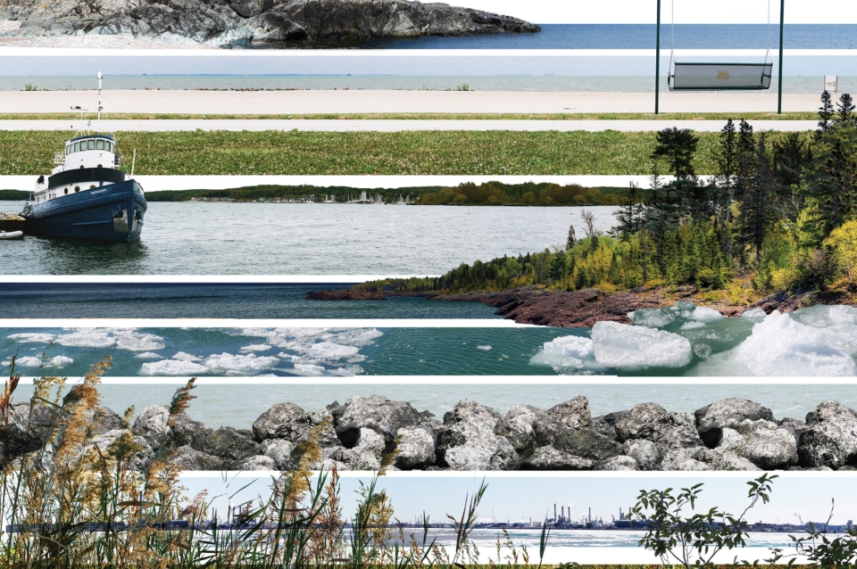
In their new book Five Bay Landscapes: Curious Explorations of the Great Lakes Basin (University of Pittsburg Press, 2022), Sean Burkholder, the Andrew Gordon Assistant Professor of Landscape Architecture, and Karen Lutsky, assistant professor of landscape architecture at the University of Minnesota and director of the Great Lakes Design Labs, call for a reset through critical, experiential, and pluralistic understandings of place. Through a series of five narratives, each located on a bay within the Great Lakes, the authors share their practice of “curious site explorations.” In this excerpt, the authors describe a journey along the shores of the Bay of Quinte on the north shore of Lake Ontario.
Dockwalking
Consider the moment of stepping out on a dock above the water. As you leave the stability of land, you hear the echo of your feet pounding on wood, the water lapping against that wood, and the gentle splashing of waves. On sunny days, this moment is accentuated by a shift in brightness, as the water’s mirrored surface amplifies the sun’s rays. The dock is a transitional infrastructure that bypasses the shallow and often “messy” area close to shore, where the water thinly covers the land, obscuring weedy plants, random organic and inorganic debris, rocky outcroppings, and muck-filled sinks. But the notion of a dock as a stable index that opposes the shifting shore is only a momentary illusion; docks themselves are also moving and messy.
To see the docks in context, perhaps it is better to be in a canoe. Paddling in and around them, their diversity material, form, and extent vary depending on era and owner. From this vantage, the stable condition of dockhood is dissolved and replaced by a ramshackle assortment of structures—decks, pontoons, piers, seawalls, and cribs—that are used to connect land and water. Some are designed with care and expertise; others appear assembled under emergency conditions with whatever materials are available. A dock does not have to be wood; any form of metal, plastic, or concrete that reaches out over the water will do. Variety is encouraged by a lack of regulations, stubborn privatization (everyone must have their own dock), and by the dynamic conditions generated by the coastal edge.
Much more than a house or a yard, a dock provides a very particular look into the mind and position of its creator. No matter where we travel in the Great Lakes Basin, these shoreline decisions display a wide range of attitudes toward the fluctuations of landscape and how residents respond to change. Individual docks showcase different stories, while collections of docks weave a larger local narrative about place. Docks must performatively juggle a series of demands to retain their identity. They must support human weight, provide some type of water access, and be able to accommodate variation in water level. A quick survey of a shoreline communicates that there is no universal agreement about the best way to meet those criteria. Questions such as whether a dock should float or be fixed on piers, or whether it should remain in the water through the winter or be removed to reduce ice damage, are answered differently. These demands are then overlaid by aesthetic decisions about what a dock looks like in relation to the bayside property. During our canoe tour, we observe a particularly notable example of the obsessive coordination of this relationship at one property where the elaborate brickwork from the home is smeared down to the water as paving material connecting two giant piers that frame each side of a concrete dock. The neighbor right next door, with an equally ornate home, has chosen instead a simple unassuming wooden structure hidden among weedy vegetation. In yet another location, the formal definition of a “dock” is strained by what appears to be a dump-truck load of concrete blocks jutting into the water. This focus on the docks might seem a bit silly or small to some. After all, it is just a dock, and millions of them are out there; but for us, they are real physical, material reflections of the desires, values, and understandings of the land-water-human relationship. People “love” the water, particularly those who own property along it, but what that “love” entails and how far it extends is not a given, particularly in a capitalistic system where property right and ownership are the rule. Entitlement is strong in this littoral band, a notion that is clear almost every time we are afforded a view from the water, the only fully public realm.
Back in the car, driving the shoreline roads, we seek out more water access. Occasionally a boat ramp or conservation area will let visitors reach the shore—or even walk out on the water—but such places are scarce. Eventually we find one tucked between a few “keep out” signs belonging to the neighbors, and we make our way out onto a well-worn wooden dock anchored to small metal piers that look considerably undersized. This is confirmed by the structure’s wobbling as we head out over the water. The submerged vegetation and a discarded dock segment leaning against a bright blue outhouse indicate that the water level has risen recently. Taking off our shoes and submerging our feet, we note other influences of high water. Shrubs that once stood on the shore now dot the water as small islands.
Conditions of shoreline privatization, prevalent across the entire Great Lakes Basin, are especially salient in the Bay of Quinte. Aside from some large parks in the cities of Trenton and Belleville, the bay is mostly inaccessible to the public, edged in a thin, protective, tightly manicured lip of private land. Thus, it is not surprising that the area is also notable for its proportion of second homes. Proximity to Canada’s two largest cities and parts of New York State make the location ideal for vacation and retirement property. While owners tend to think of these homes as separate from the city—a break from urban life—scholars such as Nik Luka have argued that “cottage country” (as
What compels so many people to own a cottage on a lake? Luka points us to B. K. Sandwell’s observation, “The plain fact is that the Canadian will not summer anywhere except beside a lake. It does not matter much how large the lake is, nor how clean, nor what sort of odors emanate from it. A lake is a lake.” Sandwell goes on to say, “Merely to dwell alongside a lake is good, but it is not everything. The true ideal of summer residence is to own a lake, so that you may dwell by it and nobody else can. . . . It is not that he is unwilling to share the use of his lake, or the fish of his lake. . . . What he wants is to be able to walk all around the blessed thing and say to himself, ‘This is mine. If I like I could drain it dry and nobody could stop me.”(2)
The opportunity to own an island within a lake affords similar feelings of complete ownership and control, and it too is possible in places like the Georgian Bay, at the western extent of the Trent Severn Waterway, where glaciers carved the bedrock into “thirty thousand islands.” There, access is further privileged, as many people own islands only accessible by boat or plane.
Wolfe and Luka have studied this phenomenon in the Canadian context, and they reach similarly troubling conclusions, finding second homeownership to be a means of asserting class by owning something inessential. Understood as part of the urban system, cottage country is in continual transformation. In many places, it is now more like suburban fringe development than rural retreat. Compounding the fiction of the stable-state cottage in solitude from the city is the fiction of the stable-state shoreline environment. As the many wayward and wonky docks, platforms, and seawalls reflect, variations in water levels critically influence any built structure. Not only do these fluctuations undermine building foundations, but policywise they also challenge property owners’ rights of control over the land exposed during times of low water. In theory, this newly exposed land could open up the lakeshore to a larger public, but between the “keep out” signs and the often misguided moves to build closer to the water, such action is unlikely to be accepted by the current residents.
In 2012 the Ontario legislature failed to pass the Great Lakes Shoreline Right of Passage Act, which would have allowed public pedestrian access to areas between the high and low water levels.(3) Strong opposition to the bill showed the power of landowners and their desire to control access to “their” waterfront. The dynamics are slightly different in the United States, where the public trust doctrine that governs the Great Lakes is interpreted differently by each state, but the general sentiment is very much the same. Most of the shoreline is something people want to own and control as private property to the exclusion of others.(4) Within larger cities such as Milwaukee, Chicago, Cleveland, Detroit, Buffalo, and Toronto, there are many more large, publicly accessible waterfronts. In these cities, which have more funding and more people, public lands continue to grow as cities reclaim old industrial sites. But as one leaves these cities—driving north just a couple of miles from downtown Milwaukee, for example—continuous public water access quickly dwindles to an occasional park between stately homes. For many visitors, shoreline privatization is evident not just in the Bay of Quinte, but across the entire Great Lakes Basin.
In many ways, Quinte could be held up as a regional success story. It appears to have a stable and growing economy tied to a strong sense of place and local identity. Stopping for drinks at the Drake Devonshire, a posh, art-themed boutique hotel in the small town of Wellington, we admire how the compound is tucked quietly into the residential area of the town, accessible by way of a small alley. Approaching the water’s edge, the hedges and fencing become extravagant, and so do the automobiles parked nearby. Fancy designer chairs are strewn out over a wonderful rock beach surrounded by rentable suites with rates exceeding $1,000 per night. Here there are no signs, but indeed literal fences preventing hotel guests from wandering onto the surrounding properties. Feeling underdressed, we sip our expensive drinks and stare out at the water. We wonder if this experience is what the “slow food” movement aspires to. If so, then it is the likely future for other prospective regions across the basin, where tourism and privatization are not yet so extreme. A 1990 US Geological Survey report identified 83 percent of the Great Lakes shoreline as private land, and the percentage is likely higher today.(5)
Thoughts of that dwindling 17 percent linger as we sit in our fancy chairs. We cannot afford more drinks, and there is now a line of people waiting to get in. Our drinks turn out to be ironically sobering as the prized lake view is overpowered by the sights and sounds of lavish dinners and clinking wine glasses.
Leaving town the next morning, we drive back through the governmentally designated and bound Mohawk community of Tyendinaga, and the agricultural poché that fills the gaps between towns and cities. We struggle to reconcile our own access and relationships to the beautiful and bucolic landscapes of the Great Lakes with the reality that all of this, whether good or bad, well intentioned or knowingly destructive, has been produced and is governed by operations of settler colonialism, environmental control, and capitalism. Now covered with cottages and hobby farms, the landscape is being colonized a second time, driven (again) by the assumption that what was here before was empty, quiet, and open for “improvement.” In many ways it is easier to decry the negative impacts of large industries with smoke-spewing factories and massive concrete pads than to come to terms with the more emotional and complicated issues embedded in the new colonizing landscapes of leisure and enjoyment. While care and joy often characterize the tourism, privatization, and local heritage of these waterfronts, the sites are also entangled with their own injustice and wastefulness.
1) Luka, Nik. “Contested Periurban Amenity Landscapes: Changing Waterfront ‘Countryside Ideals’ in Central Canada.” Landscape Research 42, no. 3 (2017): 256–276.
2) Sandwell, B. K. “Us Amphibious Canadians.” In Pocketful of Canada, edited by J. D.
3) Craitor, Kim. “Bill 103: Great Lakes Shoreline Right of Passage Act.” Legislative Assembly of Ontario, 2012. https://www.ola.org/en/legislative-business/bills/parliament-40/session….
4) Norton, Richard, Lorelle Meadows, and Guy Meadows. “Drawing Lines in Law Books and on Sandy Beaches: Marking Ordinary High Water on Michigan’s Great Lakes Shorelines under the Public Trust Doctrine.” Coastal Management 39, no. 2 (2011): 133–157.
5) Folger, D. W., Christian Andreasen, and M. J. Chambers. “US Great Lakes Shoreline Mapping Plan.” National Oceanic and Atmospheric Administration Open File Report 90–97 (1990). https://pubs.usgs.gov/of/1990/0097/report.pdf.
 Expand Image


