The central Delaware is central to Philadelphia’s future. The time to take action to create a vibrant, open, green, connected central Delaware riverfront is now.
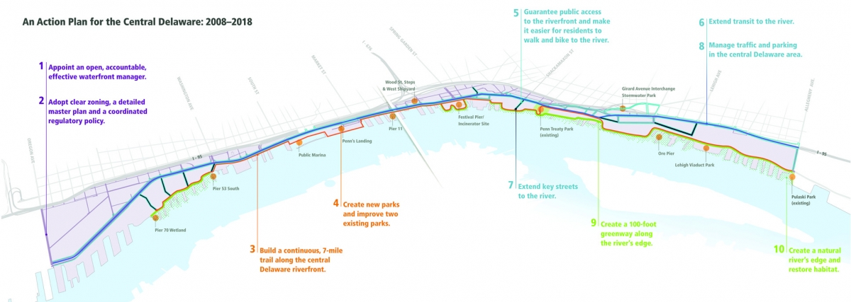
Summary Map: Ten Objectives in Ten Years
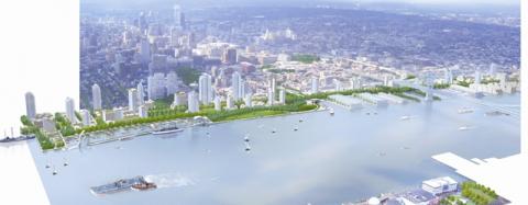
Philadelphia has an extraordinary opportunity to create a world-class riverfront along the central Delaware, but it must act now. Rapid, dramatic change—in the form of hundreds of millions of square feet of new housing, entertainment and retail uses—is coming to the central Delaware. The critical decisions we make today about this vital natural asset and development opportunity will define the riverfront’s future for the next century. We must seize the opportunity to do it right. We will not have a second chance. By investing in parks and open spaces, establishing clear development rules and creating an effective waterfront manager, Philadelphia, like cities around the world, can capitalize on its waterfront’s significant potential for recreation and economic development.
Philadelphia has the vision to make the central Delaware a vibrant, open, green and connected riverfront. In 2006–2007, four thousand Philadelphians partnered with Penn Praxis (the clinical arm of the School of Design of the University of Pennsylvania) to create A Civic Vision for the Central Delaware, a thirty-year roadmap for the riverfront from Oregon Avenue to Allegheny Avenue.
The civic vision, released in November 2007, calls for the following
1. Public access to the river over paths and extended streets;
2. Parks within a ten-minute walk of every home and neighborhood;
3. A recreational trail along the river for walkers and cyclists;
4. A streetcar line along the median of Delaware Avenue/Columbus Boulevard;
5. Parking that does not ruin water views or dominate the landscape; and
6. A healthy river’s edge that includes a 100-foot greenway along its shore.
The goal of this action plan is to define concrete, doable actions needed to redevelop the river over the next ten years in agreement with the civic vision.
Immediate Actions Needed to Protect Riverfront Opportunities
1. Adopt the civic vision and this action plan and sign a memorandum of understanding establishing the vision as the basis for interim
development review.
2. Reform Penn’s Landing Corporation to make it an open, accountable and transparent waterfront manager.
3. Add a zoning overlay under the existing zoning code to set rules for riverfront public spaces, public access and parking.
4. Preserve the Belt Line median of Delaware Avenue/Columbus Boulevard for transit and rail.
5. Plat street extensions to connect the city with the river.
Ten Action Plan Objectives
1. Appoint an open, accountable, effective waterfront manager. This action plan proposes a reformed Penn’s Landing Corporation as waterfront manager, because it has the powers and annual revenue needed to rapidly and effectively transform the riverfront. Reforming Penn’s Landing Corporation into a transparent, open and accountable waterfront manager will require changes to board membership, the application of the Sunshine Act and open-records law, and an overhaul of its governance and budget processes.
2. Adopt clear zoning, a detailed master plan and a coordinated regulatory policy. In 2008, pass a zoning overlay that ensures public space, active ground floor uses, urban setbacks, and concealed and reduced parking at the riverfront. With interim zoning in place, the Zoning Code Commission can create comprehensive zoning for the central Delaware. A master plan will provide a detailed physical-development plan for the area to guide investment, while a memorandum of understanding between government agencies at all levels will ensure a coordinated approach.
3. Build a continuous, 7-mile trail along the central Delaware riverfront. The trail will connect neighborhoods, create a recreational asset and attract investment. The Schuylkill River Development Corporation estimates that the $170 million public investment in the Schuylkill Banks trail will bring in $2.4 billion in private investment over the next decade.
4. Create new parks and improve two existing parks. Riverfront parks are extraordinary assets that raise adjacent property values by 30 percent and create new public spaces for residents to enjoy. By building destination public parks and encouraging private open spaces, we can anticipate a return of four private dollars for every public dollar spent.
5. Guarantee public access to the riverfront and make it easier for residents to walk and bike to the river. More than sixty thousand people live within a ten-minute walk of the central Delaware River, but physical obstacles such as I-95 make the river difficult to reach. Philadelphia can guarantee public access through zoning that requires all new developments to provide safe, public river access from the nearest public street.
6. Extend transit to the river. The future of the central Delaware must include a reliable public-transit system. By adding a streetcar line along the existing right-of-way in the median of Delaware Avenue/Columbus Boulevard, the city will add the equivalent capacity of two and a half car lanes in each direction. Peer cities have obtained a return on public investment exceeding 1000 percent for a streetcar line.
7. Extend key streets to the river. Extending key east-west streets that currently dead-end at I-95 or Delaware Avenue/Columbus Boulevard through parking lots, service roads or vacant private land will significantly increase public access to the river.
8. Manage traffic and parking in the central Delaware area. To avert a traffic crisis caused by thousands of additional cars on already-congested roads, the action plan recommends traffic-signal synchronization to reduce congestion by 10 percent, a new streetcar line to carry the same number of people as five traffic lanes and improved bicycle and pedestrian connections to increase Delaware Avenue/Columbus Boulevard’s capacity by up to 10 percent. Parking-design standards are also needed to prevent cars from dominating the riverfront.
9. Create a 100-foot greenway along the water’s edge. Restricting development within 100 feet of the river’s edge (or not more than 20 percent of a property) will improve river-water quality, create habitat where fish and wildlife can thrive and raise surrounding property values by 10 to 20 percent.
10. Create a natural river’s edge and restore habitat. Restoring wetlands along the river’s edge, cleaning trash and replacing bulkheads with natural shoreline will improve water quality, wildlife habitat and the river’s health.