
A Civic Vision For the Central Delaware: Movement Systems
The central Delaware riverfront is host to a tangle of infrastructure that reflects centuries of development and large-scale projects. I-95 cuts a wide swath through the entire central Delaware, and in most cases it separates residential communities from the river. Sewer outfalls reach the river every few blocks, running directly
under the I-95 viaduct where it depresses in Center City and under city streets throughout the project area. Remnants of the city’s great railroad infrastructure along Delaware Avenue and Columbus Boulevard include remainder rail lines and rights-of-way. The scale of this infrastructure presents great challenges to the city, but it also presents opportunities to enhance the riverfront in the near term and to set up decision-making that could be transformative for the city in the future.
The central Delaware riverfront is generally dominated by automobiles and is difficult to traverse on foot and bike. This lack of balance is caused by land-use regulations that do not encourage urban forms of development, the tangle of I-95/676 and Delaware Avenue/Columbus Boulevard serving as a high-volume arterial highway. The riverfront is also inadequately served by public transit, and sidewalks at riverfront destinations are often narrow, disconnected and sometimes lacking altogether. To create an active riverfront, the city should aim to balance land-use transportation policies that support the creation of dense urban form.
Strategic decision-making will be important to achieving a multimodal, dense and walkable riverfront. With development expected to increase in the coming years, phasing will allow for increased car capacity while improving the pedestrian environment on a new boulevard. It is certain that the central Delaware will continue to have traffic congestion—all successful urban areas do—but it should be managed so that a balance exists between modes of transit, with forward-thinking policies and actions reflective of the goals of this vision. Most importantly, in the course of managing growth on the central Delaware, decision-makers should be sure to avoid short-term fixes that preclude long-term gain. One look at I-95 reveals the difficulty of changing large-scale infrastructure decisions once construction is complete.
Movement Systems (pdf)
Purpose
This civic vision offers Philadelphia the opportunity to improve movement systems along the central Delaware riverfront by increasing opportunities for public access to the riverfront and shaping urban development through infrastructure investment and land-use and transportation policies that allow for multiple transportation modes.
General Findings
The project team compiled research to gain quantitative and qualitative support for various movement strategies. Research indicates that a well-connected street network with redundant paths, and intersections disperses traffic across a wide area, as it allows vehicles multiple ways to access the same destination. Areas with higher concentrations of intersections are areas with higher potentials for accessibility, which creates better riverfront access and improved traffic conditions. Effective movement strategies also rely on public transit, including land and water transportation. The Urban Land Institute estimates that the minimum density needed to support light rail is twenty-three residents or 125 employees per acre. These density levels already exist in many places in the project area.
Movement Systems Goals
To create a framework for dense, urban development along the central Delaware riverfront that is pedestrian-scaled with ample public access, the following movement systems are recommended:
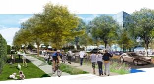
1. Envision a New Boulevard: Create a new Delaware Boulevard— a pedestrian-oriented, landscaped, multimodal boulevard along the riverfront.
2. Extend Philadelphia’s Urban Fabric: Create a street network that extends the city’s existing street grid on the west side of I-95 to the river, including a network of sidewalks and continuous riverfront access.
3. Expand the Transit System: Establish policies that minimize the impact of traffic and parking on the environment, support new riverfront activity and increase connections to neighborhoods and existing transit lines.
4. Embrace Innovative Infrastructure: Approach the reconstruction of I-95 as a transformative investment that will increase connectivity to the riverfront and stimulate significant economic growth.
Achieving these goals is possible in the long term, but it is important to remember that decisions can and will be made in the short term that will affect the long-term realization of the civic vision (as outlined in the “phasing” diagrams in Chapter Nine). Though we must not preclude long-term gain, these short-term steps can be taken by the city and the state to provide the initial framework of public access and urban development.
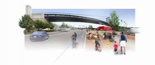
(Delaware Riverfront Trail Early Action Project: The intent of the provisional trail alignment is to create a continuous waterfront trail that can be implemented immediately using available resources. Nodes such as this one at the Ben Franklin Bridge will provide starting points, rental stations and places to rest along the trail.)
Early Actions
Movement networks create a framework that determines the form and density of riverfront development. In the short term, community and political leaders can help ensure the long-term stewardship of the goals of the civic vision with these early action projects that increase connectivity and serve to create a new way of thinking about transportation:
Finalize the proposal by the Center City District for a two-mile, riverfront trail running from Pier 70 to the Ben Franklin Bridge at the river’s edge.
Prepare feasibility studies on the future transportation network to serve the riverfront, including short- and long-term mitigations of the impact of I-95 and the creation of Delaware Boulevard and a supporting street network.
Plan for a street grid that extends key streets to the riverfront and begin the platting process to adopt these key streets on the official city plan.
Establish an interim zoning overlay that codifies the goals of the civic vision by mandating minimum public-access requirements to ensure ample points of connection (both physical and visual) between the city and the river.
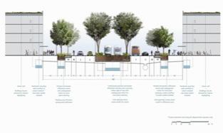
(Delaware River Conversion: The current size of Delaware Avenue/Columbus Boulevard is the result of managing traffic without an integrated network of streets connecting riverfront development to the boulevard and the network to the west. The street section above illustrates the short-term six-lane boulevard that will be possible when a street network is implemented.)
Goal 1: Envision a New Boulevard
Create a new Delaware Boulevard —a pedestrian-oriented, landscaped, multimodal boulevard along the riverfront. The transformation of the central Delaware riverfront into a local landmark and a regional destination can be accomplished by the creation of Delaware Boulevard as the spine of all riverfront activity. This boulevard will connect all development at the river’s edge and shape the identity of the reinvigorated central Delaware.
The proposed Delaware Boulevard offers multimodal transportation options as a part of a larger network that will emphasize the movement of goods and people and provide signature street frontage and access to high-quality urban development. Buildings with civic character will line the boulevard, creating new destinations east of the I-95 barrier and increasing street activity.
Discussion
The civic vision calls for the proposed Delaware Boulevard to become a part of an integrated transportation network that works in conjunction with secondary and tertiary streets to maximize access and disperse traffic. When combined with a more complete street network, mass transit, increased pedestrian and bicycle access, and transportation and parking policies that manage traffic flow, this plan may reduce the number of traffic lanes necessary on the boulevard.
In the short term, the boulevard will remain at its current size to support existing and proposed development. Traffic will undoubtedly increase in some areas along the central Delaware as development continues, and without a built-out street grid, congestion on the proposed Delaware Boulevard will worsen. But an examination of cities with connected riverfront networks can be instructive. For example, initial traffic counts following the two-week shutdown of Seattle’s I-5 in the summer of 2007 showed that highway traffic was “diffused to other routes,” causing no significant congestion incidents over the two-week period. Other cities have benefited as well from making auto corridors more pedestrian-friendly.The city of San Francisco, for instance, has replaced a section of its Central Freeway with the tree-lined Octavia Boulevard.
Early Action
The creation of Delaware Boulevard should begin with a few key steps. Although these early actions may be difficult and will require political strength from the city and the state, the landscape must be altered in the short-term if the long-term vision is to be realized:
Add key segments of the boulevard beyond existing rights-of-way to the official city plan. The diagram at the left illustrates initial actions that will allow for the extension of Delaware Boulevard to the north:
Recommendations
The civic vision recommends that the city establish the alignment for Delaware Boulevard using existing rights-of-way and key acquisitions to make connections. The following are short- and long-term recommendations for implementing the boulevard.
Short-Term Recommendations
In the central-southern portions of the study area, establish the framework for Delaware Boulevard using existing right-of-way, including these:
In the central, Delaware Avenue/Columbus Boulevard (Marlborough Street to Washington Avenue).
In the south, Columbus Boulevard (Washington Avenue to Oregon Avenue).
Establish collaboration between city and state agencies to ensure the implementation of Delaware Boulevard.
Identify where excess rights-of-way exist that can be used for widened sidewalks or additional bicycle lanes.
Long-Term Recommendations
In the long term, make Delaware Boulevard two traffic lanes in each direction for most of the project area.
Keeping a two-way street along the riverfront will increase accessibility and visibility, supporting retail development.
Design and construct Delaware Boulevard for a desired operating speed of 25 to 30 miles per hour to promote pedestrian activity.
Provide a continuous landscaped median along its center that can accommodate future transit service.
Provide landscape treatments that can help with stormwater management along the boulevard.
Provide dedicated bicycle lanes on both sides of the boulevard and a multi-use riverfront trail to accommodate both recreational and commuter cyclists. The proposed trail is described further in Chapter Six, “Parks and Open Space.”
Provide sidewalks of 10 to 24 feet wide on both sides of Delaware Boulevard to allow ample space for pedestrians. Where appropriate, the widened sidewalk will take the place of an on-street parking lane.
From Lehigh Avenue to Allegheny Avenue, build the boulevard closer to the river’s edge to maximize the redevelopment potential of the Port Richmond rail yards and to connect to the Delaware Avenue extension that is being developed along the north Delaware by the Philadelphia Department of Streets.
In the south, as the area redevelops, reconstruct the boulevard further inland to allow for separate cartways for passenger cars and trucks needing access to the working port.
Connect Delaware Boulevard westward into the city at key arterials, such as Allegheny Avenue in the north and Oregon Avenue in the south.
Goal 2: Extend Philadelphia’s Urban Fabric
Create a street network that extends the city’s existing street grid on the west side of I-95 to the river, including a network of sidewalks and continuous riverfront access.
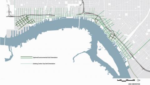
A new street grid is essential for the creation of an integrated, multimodal transportation network. The street grid imagined in this civic vision is one logical continuation of the existing Philadelphia grid, which we extend to the river in order to increase connectivity, create continuous public access to the river and relieve traffic congestion.
Discussion
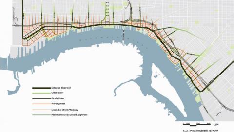
There are many advantages to applying the Philadelphia-scale street network to the riverfront. The movement network shown on page 78 would add 40 percent more vehicular capacity, offer over three times more east-west neighborhood connections to the river, and add numerous additional north-south streets. This type of network can also increase route choice for cars, bikes and pedestrians, as well as boasting mass-transit use, as more citizens use transit if walking in an area is easy and interesting. A smaller block size maximizes visibility and access, which benefits developers and businesses. In 2003, Milwaukee introduced a new street grid, and it has since seen over $600 million in nearby development.
There are also public health and ecological benefits to a well-designed street grid. A 2003 Bay Area survey found that adding 25 percent more intersections to an area made people 45 percent more likely to walk. Center City Philadelphia exhibits this finding by leading the nation in residents who walk to work. Though more streets will increase the amount of impervious pavement, well-landscaped streets can mitigate negative effects. The civic vision identifies streets with generous rights-of-way as ideal green streets. The benefits of green streets go beyond aesthetics: a UC Davis study shows that New York City street trees are collectively worth $122 million in annual energy savings, air-quality protection, stormwater-runoff treatment and real-estate values.
The civic vision also identifies the need for smaller, secondary streets that could be service routes or pedestrian walkways. It should be noted that the grid depicted in the vision plan is just one possible way for the city to adhere to the civic principle of connecting with the river. The sample plan on page 4 outlines the essential connector streets, cross streets and green corridors. Together with new zoning guidelines, these will ensure view corridors and human-scaled pedestrian access from the city to the river. These streets can be added to the official city plan by city government through a street-platting process (see “Spotlight: Street Platting” below for more detail).
Spotlight: Street Platting
The city’s legal authority to plat, or draw, streets by adding them to the of.cial city plan is crucial to this vision's recommendation to develop an integrated road network that extends the city to the river’s edge. Changing the city plan is a process that requires approvals by the Philadelphia City Planning Commission, the Board of Surveyors and Regulators, the City Solicitor’s Of.ce, City Council and the Mayor’s Of.ce. Public hearings must occur before a plan change can be formally adopted, so that citizens and city agencies can respond to proposed changes.
New streets can be added to the city plan even if the current land con.guration does not provide appropriate space for them. If these proposed streets receive all of the necessary approvals, they will be drawn on the city plan. A building permit will not be issued for any development encroaching on these new streets unless the landowner agrees not to seek compensation for the removal of the improvements should the city legally open the street. Merely drawing the streets on the city plan does not create an obligation on the part of an owner to create a street or a .nancial or ownership responsibility for the city. The street is only created when development occurs, and a financial responsibility is only created when the city legally opens the street. The process of legally opening a street is separate and distinct from the process of platting streets on the city plan. Compensation to land owners, made when a street is legally opened, does not include the value of any improvements added to a property after a street is drawn on the city plan.
Early Actions
Given the pattern of private land ownership in the study area, implementing a new street grid, sidewalks and greenway will be a long-term process. However, several important steps toward building the street network can begin shortly.
Plan and adopt the key streets identified in this section and in Chapter Nine on the official city plan. These streets will form the initial development framework that, supported by an interim zoning overlay, will begin to define the scale and character of the central Delaware riverfront.
Begin mapping the framework grid and meeting with the appropriate stakeholders, including the city, the state, the development community and civic leaders.
Utilize existing rights-of-way in establishing improved roadway networks. For example, make the service road to the east of the WalMart site at Pier 70 into the southern stretch of River Road.
Finalize the proposed two-mile, riverfront trail running from Pier 70 to the Benjamin Franklin Bridge at the river’s edge. (This movement system is addressed in greater detail in Chapter Six).
Recommendations
The civic vision’s connected network of streets, sidewalks and the continuous riverfront greenway helps increase auto and pedestrian connectivity, improve public access to the river, improve traffic capacity and, ultimately, form urban blocks that can be adopted to serve different uses as land economics change over time. The following recommendations are offered as ways to implement this crucial aspect of the civic vision. (More detailed recommendations can be found in Chapter Nine.)
Short-Term Recommendations
Plan for a street grid with the city government that extends key streets and begins the platting process for the following streets across the project area:
Pier 70 Blvd. from Columbus Blvd. to the river.
River Rd., establish between Tasker St. and Pier 70 Blvd. and from Reed St. to Washington Ave.
Washington Ave., extend and realign from I-95 to the river.
New streets created at Penn’s Landing south of Dock St. Beach St. wider between Columbia Ave. and Susquehanna Ave.
Accommodate all modes of travel on appropriate city streets. Form a partnership with the Bicycle/Pedestrian Advisory Task Force to finalize the “Complete Streets” policy, which provides adequate right-of-way for walking, bicycling and public transportation. This could include releasing a Request for Proposal for a bike sharing program.
Prohibit curb cuts as entrances to garages or parking lots on through streets to the river so as to enhance the pedestrian experience. This entrance could be accomodated on smaller, tertiary streets.
Work with property owners to ensure that proposed developments can be integrated into the new grid. This includes Philadelphia Industrial Development Corporation (PIDC), which is considering the Conrail rail yards as a site for industrial growth, as well as big-box structures at the southern end of the project area, which will eventually become obsolete.
Long-Term Recommendations
With the boulevard as the major spine of the grid, complete a network of two-lane secondary streets. This will include a hierarchy of streets similar to that of Center City, as well as a River Road. Many of these streets could be developed in combination with privately funded development projects.
Design and landscape east-west “green streets” to provide attractive links from the neighborhoods to the river and stormwatermanagement benefits.
Identify key roads that provide a break in the grid to create visual interest and variety—for example, those that suggest the character of creeks that once fed the Delaware (such as Cohocksink Creek).
Complete an urban mobility study similar to the one conducted in Seattle (see “Spotlight” later in this section) that finds ways to boost local street connectivity and the functioning of regional thoroughfares.
![]()
Goal 3: Expand the Transit System
Establish policies that minimize the impact of traf.c and parking on the environment, support new riverfront activity and increase connections to neighborhoods and existing transit lines.
Mass transit is a critical part of a transportation strategy that aims to mitigate the auto-dominated nature of the central Delaware riverfront. This civic vision calls for expanded land and waterborne public transportation. Elements would include a transit rail line that would run down the center of Delaware Boulevard throughout the project area (once density and activity levels can sustain it), as well as a system of water taxis and ferries running north-south along the river and east-west to New Jersey.
Like Philadelphia’s street grid, the city’s regional transit network should be extended to the river’s edge in order to encourage and support higher levels of development density and activity on the riverfront.
Discussion
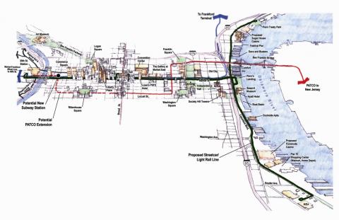
Currently, Philadelphia’s riverfront is hard to reach by public transit. While the seven-mile corridor of the central Delaware riverfront is close to the Port Authority Transit Corporation (PATCO) line and the Southeastern Pennsylvania Transportation Authority’s (SEPTA) Market-Frankford line, the central Delaware could be far better connected through a regional transportation network.
To support the amount of development anticipated for the riverfront, the city and regional transit authorities should develop a comprehensive transit plan for the region, a plan that integrates the PATCO and SEPTA systems via a dedicated riverfront rail line. Coordination with the Delaware River Port Authority (which runs PATCO) and SEPTA to determine the best transit technology for the corridor is critical. One possible technology is light rail, which costs less to build and operate per service mile than a heavy-rail subway. It is also a faster, more sustainable and more attractive option than traditional buses.
The possibility of sharing the existing freight rail line in the center of existing Columbus Boulevard with a new passenger rail service should be explored. Many passenger systems throughout the United States share the rail with freight uses (including Baltimore, San Diego, Seattle and Camden). Utilizing light rail presents opportunities for effective partnerships with local rail companies. A dedicated transit right-of-way will be necessary along the central Delaware to ensure reliability and ridership, especially as development pressures persist. Light rail and streetcar systems have played key roles in revitalizing waterfronts in areas as diverse as Toronto, Ontario; Portland, Oregon; and Baltimore, Maryland. Local leaders have already shown that they understand the economic, social and environmental benefits of an integrated transit system by authorizing DRPA to conduct a $2.1 million study on improving transit connections between South Jersey and Philadelphia. The Center City District has also recommended extending trolley access along Market Street from the Delaware River to Thirtieth Street Station. The findings of these studies must be evaluated in conjunction with the recommendations of this civic vision.
To be successful, a transportation network needs to offer variety. In Philadelphia, the RiverLink Ferry at Penn’s Landing serves an important but underutilized function as a local water taxi service, which this vision recommends expanding. Ferries and water taxis have succeeded in cities as small as Erie, Pennsylvania, and as large as New York City. The addition of smaller, more attractive and more frequent water taxis along the Delaware River would increase options for the region’s transit network.
Spotlight: Connections to Camden
The redeveloped Camden riverfront features multiple attractions, including an aquarium, a minor-league baseball stadium, a large concert venue and a riverfront esplanade. To create an active riverfront, connectivity between the two riverfronts should be increased. The civic vision proposes investigating the potential to open the former trolley stop under the Ben Franklin Bridge to connect with PATCO, as well as launching a new fleet of water taxis. Potential stops include destinations along Camden’s riverfront, Petty’s Island—an important open-space development opportunity on the Delaware River— and the proposed casinos. Together, improved land transit and water taxis will increase access between the two riverfronts.
Early Actions
Developing a complete transit system is a long-term endeavor. However, important short-term applications can be implemented before the needed build-out population and employment densities are established.
Coordinate with DRPA and SEPTA to ensure that the recommendations in this vision are incorporated into their riverfront-transit studies, including exploring the option of opening the Ben Franklin Bridge trolley stop to PATCO trains.
Study opportunities for connections between the central Delaware riverfront’s proposed transit additions and the existing transit lines beyond Penn’s Landing. Focus sites could include SEPTA’s Market-Frankford El at Spring Garden Street and the proposed Route 23 trolley at the Sports Complex.
Begin discussions with representatives of CSX and the Philadelphia Belt Line Railroad about the possibility of sharing the line with passenger service.
Recommendations
Public transit is key to ensuring that the civic vision can be successful. Different forms of transit have specific demands (land use, density, urban design) that must be met to ensure their success, both in ridership and land use benefits. The following recommendations outline steps that will bring Philadelphia closer to having the high quality riverfront its citizens desire.
Short-Term Recommendations
Create phases for the implementation of this transit plan. In the initial stages, the city could utilize buses that run in mixed traffic. Then, once ridership can support it, the city could designate a cartway on Delaware Boulevard for interim transit, such as Bus Rapid Transit.
Coordinate a study by DRPA and SEPTA to develop an implementation plan for mass transit on the riverfront. The study should explore possible connections to the Sports Complex, the Philadelphia Navy Yard, and existing and future subway stations along Broad Street.
Establish a system of water taxis and ferries to support new riverfront activity and provide connections north-south along the river and east-west to Camden.
Long-Term Recommendations
Build a rail transit line with dedicated rights-of-way to serve riverfront communities, and connect it with existing transit lines.
Utilize the existing rail right-of-way along a portion of Columbus Boulevard and a portion of Weccacoe Avenue for transit.
Use modern, sustainable technologies for vehicle and track design.
Develop a transfer station at Penn’s Landing. This location would offer connections to the Market Street surface trolley envisioned by the Center City District as well as to water taxis and ferries.
Provide regional connections to PATCO by reopening the Franklin Square station, and investige the feasibility of using the station located in the western abutment of the Benjamin Franklin Bridge.
Goal 4: Embrace Innovative Infrastructure
Explore the reconstruction of I-95 in Center City as a transformative investment with that will increase connectivity to the riverfront and stimulate significant economic growth.
I-95 runs north and south through the central Delaware project area. It blocks movement from the city to the river, allowing for only two streets to cross to the riverfront at grade without the viaduct overhead: Spruce Street and Dock Street. In the near term, the creation of a multimodal boulevard, greater transit options, progressive urban land-use policy and quality development will lessen the barrier effect by invigorating the riverfront with residents and visitors. While ideas to bridge the divide created by I-95 at Center City have circulated for many years, the reimagining of I-95 is a collaborative effort that the city should undertake with state and federal partners to realize the central Delaware’s full potential. The success of the central Delaware riverfront should not be contingent upon I-95 being buried. As noted in this vision, in coming years the city and state will have opportunities to recreate Penn’s Landing as a green space, provide greater development opportunities on surrounding parcels and enhance the riverfront north and south of Center City. And, the planned rebuilding of the entire Philadelphia segment of this federally funded highway in the coming years presents the city with an opportunity to transform the way Center City meets the riverfront. The section of I-95 that runs along the central Delaware riverfront project area will be reconstructed between 2008 and 2040.
Reconfiguring I-95 to connect Center City with the river would be a major project. Determination of economic feasibility is years away, but the city and state should begin the process of exploring options today to ensure that this type of transformative infrastructure improvement is not precluded.
Discussion
Construction of I-95 began in 1959, a time when abundant federal dollars financed highway construction. The highway design of that era featured functional, elevated structures located in commercial sections of downtowns and along industrial waterfronts. In today’s Philadelphia, almost 200,000 cars per day move north and south on I-95 each day, travelling within Philadelphia and between neighboring states.
Spotlight: Seattle
As its regional population increases, Seattle is developing a comprehensive traf. c and transportation policy that addresses connectivity issues within the city. Its innovative traffic control program has constructed hundreds of speed humps, curb-bulbs and traffic circles and has helped community groups work with police to monitor local traffic. Seattle is also exploring alternatives to the Alaskan Way Viaduct, its double-decker highway that runs along its waterfront, in its Urban Mobility Plan. Its City Council charged the Seattle Department of Transportation to develop an alternative to its proposed new waterfront highway: new surface streets and increased public transit. Though eliminating I-95 altogether is not a viable option for Philadelphia, Seattle’s initiatives demonstrate a change from traditional thinking about regional connectivity that Philadelphia ought to consider.
The reconstruction of the highway presents us with the opportunity to enhance connections between the city’s neighborhoods and the riverfront. PennDOT is in the process of rebuilding I-95 through a routine renewal cycle. It has already completed plans for the Girard Avenue Interchange, which will reconfigure the structure from Allegheny Avenue south to Race Street. Ground-level roadway construction is slated to begin in January 2008. PennDOT plans for the reconstruction of the portion of the interstate south of Christian Street to begin in 2020 and for reconstruction of the sunken section in Center City to begin in 2032.
This civic vision explores both short- and long-term measures to mitigate the impact of I-95 on the central Delaware. Short term initiatives include at-grade improvements around I-95 that increase connectivity. Recent designs for the Girard Avenue interchange can be used as a prototype for future interchange design. Further, capping the highway for some portions of the central section should be investigated as a short term economic development strategy.
In the long term, the rebuilding of the Center City portion of I-95 has the greatest opportunity to transform the central Delaware as a regional destination. An initial civil-engineering analysis indicates that depressing I-95 to allow for street-level connections from the neighborhoods to the river is technically feasible. With the portion of I-95 that rises to pass over the Market-Frankford Line representing a significant physical, visual and psychological barrier between the oldest portions of the city and the river, it is crucial that further study be conducted in order to reestablish this important connection with the river at the foot of Market Street.
This vision plan also recommends that PennDOT further investigate the economic, environmental and engineering feasibility of depressing I-95 at Center City. While this section of the highway is not slated for reconstruction for another twenty-five years, now is the time explore its feasibility and to plan for a rebuild that will support long-term connectivity between the river and the city.
I-95 is a vital regional transportation link, and traffic is an inevitable part of city life. Yet other cities have found ways to make urban highways function as one part of an urban cityscape. After an earthquake destroyed its waterfront highway, San Francisco replaced it with an urbane boulevard, while Portland and Providence removed stretches of their highways to gain riverfront access. Plans for decking highways with developable cover are also being widely accepted around the country, including in cities such as Dallas, Saint Louis, Cincinnati and San Diego.
Federal highway funding is beginning to be used to help cities manage congestion and improve their infrastructure. Cities such as New York, Seattle and Miami received federal funding this year to address their congestion challenges. Additionally, a new plan for New York City’s F.D.R. Drive calls for the construction of new public spaces, new aesthetic treatments and a modern lighting scheme around the highway. Underneath the highway in Louisville, a 55-acre brownfield site was redeveloped into an expansive riverfront park that includes both passive and active spaces along the Ohio River. Though states currently struggle for funding, many believe that more federal funds will be available for urban infrastructure investments in the near future (see “Spotlight: Transformative Investments” below).
Early Actions
Infrastructure improvements happen on an incremental cycle. Long- term decisions require near-term planning.
Begin the next phase of a comprehensive planning study that examines the potential movement and transportation network for the study area, including the redesign of I-95 and the creation of Delaware Boulevard and the local street network. This study should involve both state and local agencies.
Ensure that funding is allocated for at-grade improvements in the Girard Avenue Interchange redesign.
Plan future stages of PennDOT’s I-95 redesign to conform with the civic vision.
Consider short-term solutions to soften the barrier of I-95—such as public art, lighting and landscaping—as reconstruction will not occur for decades.
Recommendations
Currently I-95 acts as a psychological and physical barrier separating Philadelphia’s neighborhoods from the riverfront. Through a series of infrastructure investments, this civic vision offers various methods of reducing this barrier. The following recommendations identify a variety of infrastructure investments that could contribute to the creation of a premier riverfront. These include short-term at-grade improvements as well as the long-term possibility of capping or tunneling the central portion of I-95.
Short-Term Recommendations
Implement the following improvements to the current design for the Girard Avenue Interchange, as envisioned in collaborative workshops with PennDOT:
Narrow lane widths and widen sidewalks along the new portions of Richmond Street and Delaware Avenue that PennDOT will construct as a part of this project.
Provide landscaping and amenities that will promote the use of the area under I-95 for recreation and access and provide a pleasant connection to Penn Treaty Park and the river. The construction and maintenance of recreation facilities should be coordinated with the city, PennDOT, property owners and other stakeholders.
Use newly available land on either side of Richmond Street for landscaping or park space.
Conduct a feasibility study for the proposed transportation network along the central Delaware that considers these solutions:
Reconstructing I-95 at Center City to address its barrier effect.
Constructing Delaware Boulevard where right-of-way currently does not exist.
Using technologies such as signal synchronization and lane control to make Delaware Avenue/Columbus Boulevard more efficient as auto traffic increases.
How traffic volumes can be maintained without widening existing roads.
Exploring ways to address issues underneath and around the highway through at-grade improvements.
Begin collaborative partnerships between city, state and federal agencies (such as PennDOT and the Philadelphia Water Department) that could result in new ways of thinking about infrastructure along the riverfront.
Long-Term Recommendations
During the long-term reconstruction of I-95 from Spring Garden Street to Washington Avenue, consideration should be given to using one of the following alternatives:
Cap the central stretch of I-95 in the highway structure currently designed, or
Depress I-95 (with Callowhill Street as the northern boundary) in the current right-of-way, allowing urban-scale development above the interstate.
Realign I-95 beneath the current Columbus Boulevard in a tunnel, and use the old interstate right-of-way for development.
Using the collaborative designs created for the Girard Avenue Interchange as a prototype, implement these and other ground-level improvements to reduce the divide created by the elevated highway:
Build the elevated highway on structure, not an embankment, thus preserving a view of the river from the neighborhoods allowing for physical access under the highway.
Extend dead-end streets under the highway to continue the street grid.
Design elements of I-95 at key through-streets to establish attractive civic portals that enhance pedestrian connections to the river and that use attractive lighting, public art and high-quality materials.
Line the highway structure with landscaped sound walls to create a more effective noise buffer and environmental treatment.
Provide high-quality, contemporary urban lighting underneath I-95.
Prohibit billboards on either side of I-95 in the project area.
Eliminate redundancies in the I-95 ramp system in the project area between Race Street and Bainbridge Street in light of the proposed addition of a southbound exit ramp to serve Foxwoods Casino.
Spotlight: Transformative Investments
Though federal funding for urban infrastructure projects has been in decline in recent years (indeed, the federal highway trust fund is reported to be facing a deficit), recent events such as the 2007 failure of the Minnesota I-35W bridge have focused public attention on the nation’s underinvestment in infrastructure. This vision recommends that attention be given to the potential for future federal funding of what the Brookings Institution calls “transformative investments” in urban-infrastructure projects—projects that restore the physical landscape and successfully stimulate economic growth. While the current economic and political climate does not support these kinds of projects, the civic vision recommends that Philadelphia position itself for “transformative investment” in the coming decades, when it is believed that Congress will again be investing in cities. Private investment can also be utilized in such a large-scale project as redesigning I-95. If developable cover is built over the Center City stretch of I-95, development air rights can be leveraged for infrastructure funding. Through a combination of traditional federal funding sources and new funding sources, cities and states can work together to address public infrastructure in a meaningful way. In order to maximize opportunities for future funding, it is important that Philadelphia begin preparing for the possibility of transformative investments today.
In addition, this civic vision recommends investigating coordination between PennDOT and the Philadelphia Water Department (PWD), which is under a federal mandate to address the city’s aging sewer infrastructure. PWD is currently considering the use of high-tech tunneling equipment that could possibly be used in the highway reconstruction as well. Although any project of such magnitude would require signi.cant political will and public investment, it is necessary that government entities coordinate efforts to make large-scale improvements possible.