
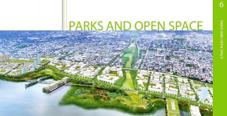
A Civic Vision For the Central Delaware: Parks and Open Space
The central Delaware riverfront is severely lacking in public open space, but it has the potential to host a world-class park system. Currently, there are only two public parks in the project area, Penn Treaty Park and Pulaski Park, and these occupy just eight of the area’s 1,146 acres. Another possible park location would be Penn’s Landing, a hard-surfaced, significantly underutilized public asset in need of revitalization. A more extensive, contiguous and designed system of open spaces at the river’s edge would improve quality of life for neighbors, increase the value of future development,preserve and support natural life and attract visitors from across the region.
Parks and Open Space (pdf)
Purpose
The purpose of the following recommendations on parks and open space is to improve the quality of life along the riverfront and the river itself by building a network of public open spaces that are ecologically productive and attractive. This sustainable system would serve local residents while improving the area’s economic viability.
General Findings
In addition to engaging the community in defining its vision for the central Delaware riverfront, the project team researched the numerous benefits of a coordinated parks-and-open-space system. We found that the economic impact of open space on land development is significant. Examples from cities around the nation, including Boston, Chicago, San Diego and Philadelphia, show that the land within close proximity to a park is typically the most valuable downtown land in the city. Even smaller projects, such as the greening of nearby streets, were found to have a significant effect on property values.
Higher property values are not the only benefit of greening a city’s spaces; parks and trail systems themselves generate significant tax revenue for the city, as they are relatively inexpensive public investments compared to road infrastructure and are a big draw for residents and visitors.
Parks and open spaces also have important health benefits for residents, as well as for the city as a whole. Having such recreational assets increases activity levels and therefore improves the health of neighbors and visitors. In addition, with issues of climate change and energy efficiency gaining international attention, parks must be considered for their ecological value. Along the central Delaware riverfront, parks can serve the productive purpose of minimizing the negative effects of pollution on the watershed. The proposed natural green spaces along the riverfront could contain stormwater runoff, trap sediments, provide natural habitats and mitigate flooding. Once they are removed, however, natural green spaces are difficult to replace.
Parks and Open Space Goals
Based on the findings and input of citizens, planners and designers, the project team has developed the following strategic goals.
1. Create New Parks and Open Space: Develop new parks throughout the central Delaware riverfront project area to give every riverfront neighborhood a green public space.
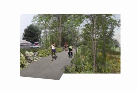
2. Connect the City to the Riverfront: Connect public open spaces with a continuous riverfront trail that will link destinations and serve as a destination for walking, jogging and biking. Utilize city streets to create green corridors and provide valuable connections to the riverfront.
3. Invest in a Sustainable Riverfront: Invest in ecologically productive parks and open spaces to ensure the long-term sustainability of the riverfront.
Early Actions
As is true along other urban riverfronts, an open-space network along the central Delaware riverfront improve quality of life and raise the development value of riverfront land. With the concurrent release of this report and GreenPlan Philadelphia, the city-sponsored comprehensive plan for parks and open spaces, regional decision-makers face a rare opportunity to begin park projects quickly to demonstrate the strength of civic-engagement processes. The team behind A Civic Vision for the Central Delaware recommends the following early actions:
Implement the interim riverfront bike trail proposed by the Center City District. The trail would run from Pier 70 to the Benjamin Franklin Bridge.
Create tidal wetlands, meadows and floodplain forest at Pier 70 in conjunction with the Philadelphia Water Department and the Pennsylvania Department of Environmental Protection.
Investigate strategies for open-space acquisition and consider potential sites for water recreation.
Create and enforce a zoning ordinance for a 100-foot riparian public easement at the river’s edge.
Goal 1: Create New Parks and Open Space
Develop new parks throughout the central Delaware riverfront project area to give every riverfront neighborhood a green public space.
The key to creating an urban riverfront destination that attracts neighbors as well as visitors is a series of parks and open spaces that are well connected to surrounding communities, public transportation and major destinations along the Delaware River. This park system will build upon existing assets along the riverfront, connect existing neighborhoods with the river and support urban development.
Discussion
Research indicates that turning a parcel into open space gives it significant economic power, because open space catalyzes quality urban development around it. For example, San Antonio’s Riverwalk was created for $425,000 and is now the most popular attraction in a city with a $3.5-billion tourist industry. University of Pennsylvania professor Susan Wachter reports a 30 percent increase in nearby property values due to the greening of vacant land. The high value of land close to beautiful park spaces is clearly shown in Philadelphia; in September 2007, a 0.83-acre lot sold for $36.7 million (at a profit of $31 million) because of its proximity to Rittenhouse Square. In 2005, Forbes Magazine named the Chicago zip code containing Millennium Park the “hottest” in the country, with a $710,000 median residential sale price. Adjacent property owners are seeing an average bonus for their units of $100 per square foot, as well as sales that are 30 to 50 percent faster than projects away from the park. Millennium Park is such a popular destination that it is projected to generate $5 billion in tax revenue in its first ten years of operation.
More importantly, an integrated park system helps create a healthy city and improves the quality of life for residents and visitors. In a survey of U.S. adults, people with access to neighborhood parks were nearly twice as likely to be active as those without access.
Early Actions
Both the Schuylkill River and the Wissahickon Creek were once lined with industry, but today their banks have been transformed into recreational sites. The trails and green spaces along the river and creek serve to improve the city’s health, offer refuge from urban life and foster economic development. Thus, these steps toward an integrated park system are important to improving the central Delaware riverfront. The following early actions can begin the process of creating a network of green spaces along the riverfront:
Initiate the development of tidal wetlands, meadows and floodplain forest at Pier 70 and identify public funding sources for construction and maintenance of these new open spaces.
Refurbish Penn Treaty Park.
Refurbish Pulaski Park.
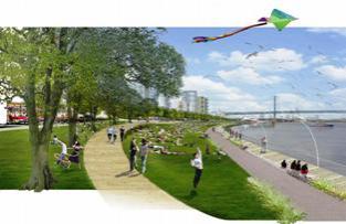
A Vision of Penn Treaty Park
Improvements to Penn Treaty Park will help to this green space retain its value as an important community asset and gathering space. Recommended enhancements include the creation of a naturalized edge and a connection to the proposed greenway. The restored riparian edge would stabilize the river/park edge, create a sustainable habitat for endemic species of plants and animals, and preserve the unimpeded view to the full span of the Ben Franklin Bridge and the new skyline of the city. The greenway and new paths will attract residents from Fishtown and the proposed waterfront developments to an enhanced neighborhood park.
Recommendations
The addition of public open spaces throughout the riverfront will position the central Delaware as a collective asset for the city and region. In order to realize this vision, A Civic Vision for the Central Delaware recommends the following actions:
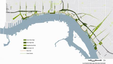
Preserve land for public open space and include public art. The vision suggests that 27 percent of land in the project area be preserved as public open space. Here are some of the recommended parks:
An expanded Pulaski Park.
In expansive green space that filters stormwater for South Philadelphia neighborhoods, at the foot of Snyder Avenue.
A habitat park at Pier 70 that incorporates tidal wetlands, upland meadows and floodplain forest.
An inland park in South Philadelphia serving areas in which port activity prohibits river access.
Public river access at the termination of Washington Avenue.
A green space beneath the Ben Franklin Bridge.
A public space at the foot of Spring Garden Street on the Festival Pier/incinerator site.
A refurbished Penn Treaty Park.
A stormwater management park under I-95 at the Girard Avenue Interchange, which could serve as a prototype for future infrastructure construction.
A space at the terminus of the Lehigh Viaduct, including the Ore Pier on the Conrail site.
A signature green space and civic marina at Penn’s Landing.
Ensure that open space relates to the river by managing stormwater and restoring river habitat through the integration of rainwater pools, native vegetation and new wetland areas.
Create or enhance public sites along the river to land and rent boats.
Establish incentives for conservation easements and private sector contributions to develop and maintain riverfront open space.
Form partnerships with federal, regional, state and local agencies to improve efficiency and share limited resources, including these agencies: Fairmount Park Commission and Pennsylvania Horticultural Society, to foster “Friends” organizations that will help neighborhood parks thrive; Philadelphia Water Department, to redevelop sites on its Tidal Wetland Registry into naturalized public spaces; and Pennsylvania Environmental Council, to extend the East Coast Greenway.
Address ongoing maintenance. Coordinating the interagency management of park resources and recognizing and promoting opportunities for public-private partnerships are essential to the health of public open spaces.
Develop a strategy for a land trust that can use city, federal and private funds to acquire land and preserve it for public open space.
Build upon GreenPlan Philadelphia’s comprehensive plan for parks, recreation and open space by developing partnerships with key federal, state and city agencies or departments to coordinate early and longer-term greening projects along the riverfront.
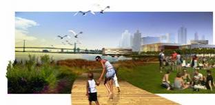
A Vision of a Great Lawn at Penn’s Landing Park
A simple and flexible park design at Penn’s Landing provides a gathering space for everyday enjoyment as well as events. As in the city’s other great parks, a “great lawn” at Penn’s Landing is in the tradition of William Penn’s vision of a “greene country towne.”
Goal 2: Connect the City to the Riverfront
Connect public open spaces with a continuous riverfront trail that will link destinations and serve as a destination for walking, jogging and biking. Utilize city streets to create green corridors and provide valuable connections to the riverfront.
The centerpiece of the civic vision for public open space along the central Delaware riverfront is the development of a continuous greenway that will allow Philadelphians greater access to the river’s edge. This greenway will function in numerous ways, including as a recreational trail, an ecological filter for stormwater and pollutants, a sanctuary for river wildlife and a supportive framework for economic development.
Discussion
Over three hundred years after William Penn permitted private development along the Delaware on the condition that public access was maintained at every block, most riverfront land in the project area is privately owned, and public riverfront access is minimal. The commonwealth holds the development rights to riparian land (see “Spotlight”) at the river’s edge in public trust. This presents us with an opportunity to create public green space that beautifies the project area, improves the health of residents, eases some burden on the city’s aging sewer infrastructure and increases land value for owners of riverfront and adjacent properties.
Today, cities around the country are creating public greenways on riverfront land. Riparian buffers increase property values and development capacity. Boston Harbor has seen over $10 billion of private investment since new trails and parks were added to its waterfront; in fact, 60 percent of the city’s population growth in the 1990s occurred in waterfront communities. Schuylkill River Development Corporation estimates that the $170 million public-sector investment in the central portion of its trail will result in $2.4 billion in private investment over the next five to ten years. Further, a riparian buffer reduces construction costs for adjacent properties by meeting some or all of their on-site stormwater-management needs. According to Penn Future, 92 percent of Philadelphians surveyed believe that environmental and infrastructure improvements are necessary to improve the area’s economic competitiveness and growth. A recent Chicago study showed that people are drawn to a river with clean water, vegetation and wildlife; a riparian greenway attracts and provides all three.
The civic vision recommends a 100-foot wide (on average) riparian edge as recommended by the Environmental Protection Agency. For urban rivers, this is the minimum buffer width required for trapping sediments and providing generalized habitats. Establishing this 100foot greenway is important, given the lessons learned through other local projects. The popular Schuylkill River trail, for example, now has limited space to expand in a 50-foot right-of-way, and its hard urban edge does not offer significant ecological protection. The north Delaware goes further by requiring that 30 feet of its 50-foot greenway be made into or left as a riparian edge, but this has also had limited environmental effects.
The proposed greenway buffer will also provide flood protection. Large portions of the hundred-year floodplain in the project area are impervious surface, so buffers are needed to lessen the physical and economic impacts of flood damage.
Spotlight: Riparian Land
The system of designating and protecting riparian land has its origins in English common law. The phrase describes the land at the river’s edge, which in Pennsylvania is held in trust by the commonwealth for public use, with the state approving riverbed leases on a case-by-case basis. This publicly owned land could be an asset in the creation of a new riverfront open-space network.
Riparian land is defined as the land that lies between the pierhead line (where a pier ends and the shipping channel begins) and the bulkhead line (the location of a retaining wall built along the riverbank). However, the shoreline of the central Delaware River has changed so much over time that there are differing opinions of where the bulkhead line lies. For this reason, few projects have been approved by the commonwealth in the past few years, even as pressure to develop riverfront land has risen.
The commonwealth has recently priced its riparian leases at $5 per square foot (a one-time fee for a 99-year lease) and added public riverfront access as a provision for private development of the land. Further, any lease payments above $250,000 can go toward public bene.t, thus representing a possible funding source for the implementation of portions of the open-space and public-access infrastructure recommended in this civic vision.
Spotlight: Water Recreation
At every public forum held in the creation of the civic vision, citizens listed water recreation as an exciting opportunity that has yet to be fully realized along the central Delaware. Therefore, the vision seeks to promote opportunities for water recreation. Water-based recreation can be an economic driver for a riverfront. In 2005, United States canoe and kayak sales exceeded $200 million and in 2001 Americans spent a total of $36 billion on fishing.
Some ways to boost water-recreation opportunities include opening multiple public marinas and boat basins throughout the entire project area; creating opportunities for more historic sailboat tours; establishing launching points for kayaks, motorboats and jet-skis; developing protected coves for paddle-boating; and creating protected swimming holes along the Delaware River (an idea currently being studied by the Schuylkill River National and State Heritage Area).
However, further study will be necessary before many forms of recreation can be recommended. According to the Pennsylvania Environmental Council, south of the Ben Franklin Bridge, the river is unsafe for inexperienced kayakers due to strong currents and wakes from large industrial ships. Further, buoys do not currently mark the shipping channel, and no landings currently exist from which kayakers could leave the water.
Early Actions
Implementing a central Delaware greenway as an early action project would demonstrate the power of the civic vision. Dedicating land for public use and environmental protection benefits residents, the economic development community and the river itself. Here are some early action steps toward this goal.
Assist the Center City District in the construction of a two-mile interim bike trail from Pier 70 to the Benjamin Franklin Bridge.
The trail will include stations for recreational-equipment rentals and refreshments.
Implement a zoning ordinance to create the 100-foot-wide riparian buffer where practicable.
Educate property owners, political leaders and the community about the economic, social and environmental benefits of extending the greenway along the length of the riverfront.
Recommendations
In order to create a comprehensive system of public open space, we should address the spaces between existing and proposed parks. Here are some recommendations for achieving this key objective:
Work with City Council, riverfront communities and the newly appointed Philadelphia Zoning Code Commission to create an ordinance establishing a 100-foot natural riparian edge where practicable along the river. The proposed greenway amenities and plantings may be contained within this buffer.
Buffer width can be increased in areas in which adjacent open space exists, or where acquisition of additional open space is possible.
Connect the greenway to neighborhoods through a series of landscaped streets that provide green links to the river as well as stormwater drainage.
Use the land under I-95 to create trail extensions and landscaped parking that maintains access to the greenway.
Establish incentives for conservation easements and private-sector contributions to the development and maintenance of the riverfront greenway and green connector streets.
Build upon the design guidelines developed for the north Delaware for riverfront trails in the central Delaware riverfront. The guidelines should ensure high-quality public art, furnishings, paving, light fixtures and landscaping.
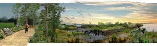
A Vision of Pier 70’s Constructed Habitat
In these depictions of a redeveloped area at Pier 70, the existing piers are detached from the bulkhead to facilitate a naturalized establishment of native species. Visitors to the riverfront trail will be able to experience this restorative process over time, as the islands become a viable habitat for birds and native plants. The combination of these industrial artifacts with the process of restoration expresses the evolving role of Philadelphia's central Delaware riverfront.
Goal 3: Invest in a Sustainable Riverfront
Invest in ecologically productive parks and open space to ensure the long-term sustainability of the riverfront.
The central Delaware riverfront presents Philadelphia with an opportunity to practice techniques for sustainable design on an unprecedented scale. River ecology is an increasingly important planning issue in light of Hurricane Katrina and concerns about climate change. Integrating ecology into development practices and public policy will benefit the riverfront and the region in the long term.
Plans for the Delaware have the potential to be ecological, equitable and profitable. This civic vision recommends that the city look beyond the short-term practices that drive current development. We can think of all our public spaces—streets, parks and others—as productive tools to ensure better water quality, air quality and public health. Even a series of small but cumulative strategies across the project area can benefit and position Philadelphia as a leader in sound planning and design.
Discussion
All citizens benefit from attention to ecological improvements. Three of the worst floods on record in the Delaware Basin have occurred in the past five years—all storm-related. The amount of tide-exacerbated flooding is projected to increase in coming years, and portions of the hundred-year floodplain vary from 50 to 2000 feet in width throughout the project area. All bulkheads in the central portion of the riverfront will likely be exceeded by water levels in hundred-year flood storms. And since much of the project area is already covered with impervious materials that prevent rainwater from infiltrating soils, the land is not able to properly mitigate the volume of water coming from the city.
This is why the riparian buffer and related plan elements are important. This vegetated buffer will help meet the city’s stormwater-management requirements for some developments, acting as a treatment facility as well as a beautiful addition to the riverfront. It will have the capacity to filter 1 inch of stormwater runoff—the performance standard—from the proposed trail and Delaware Boulevard. Thus, the addition of pervious surfaces will help manage stormwater and support the civic principles of connectivity and sustainability.
It has been estimated that 95 percent of the once-contiguous freshwater tidal wetlands on the Pennsylvania side of the Delaware have been destroyed. The decline of this habitat has had deleterious effects on the health of wildlife populations and has severely reduced the river’s ability to perform the critical functions of a healthy ecosystem. The Department of Environmental Protection now requires that the city restore or create more wetlands along its riverfronts. In addition, in its efforts to meet the federal mandate for water quality set by the Clean Water Act, the Philadelphia Water Department has identified many potential wetland sites in the project area. Two of these are the finger piers at Pier 70 and at the Girard Avenue Interchange at Dyott Street.
Other benefits of ecologically minded development are equally clear. Potential Wetland Areas Urban, vegetated and permeable surfaces are all effective ways combat the urban heat-island effect because of their capacity to reflect sunlight. A Michigan State University study shows that buildings with trees planted at strategic locations around them use 50 percent less energy for cooling purposes than they did before the planting. Further, a UC Davis study showed that the street trees in New York City are worth $122 million for the annual energy savings, air-quality improvement, stormwater-runoff treatment and real-estate sales they provide or encourage. “Green” infrastructure does far more than pay for itself over time, through these sorts of savings as well as through benefits for quality of life, public health and property value. A study by Penn professor Susan Wachter found that the simple greening of streets alone raised property values by 10 percent.
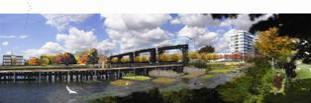
A Vision of Pulaski Park
In this depiction, an expanded Pulaski Park creates a naturalized edge along the river and provides a public landscape that grants access to the historic gantries that represent Port Richmond’s identity as a former industrial powerhouse. A grid of rafts with experimental plantings provides habitat for birds and creates a rich aquatic ecosystem for fish and nesting birds. The restored gantries pier becomes an attraction for fishing and a visual platform that offers open views to the river, the adjacent pier housing and its park, New Jersey and the area abutting Pulaski Park.
Early Actions
Ecologically sound development marries natural processes and built systems to achieve balanced environmental, social and economic outcomes. The following early actions can serve as the foundation for a sustainable community:
Include provisions in a zoning overlay that ensure that riverfront development minimizes impact on the riverbed and river habitats.
Support PennDOT in its construction of its stormwater park and trail extension under he new Girard Avenue Interchange, and consider it a prototype for future infrastructure construction.
Recommendations
Restoring nature is an essential component of Philadelphia’s investments in the long-term health, development and management of its riverfront and the city as a whole. Realizing a healthy riverfront requires the following actions:
Use federal mitigation requirements as an opportunity to create tidal wetlands along Philadelphia’s central Delaware riverfront.
Designate a continuous riparian buffer (minimum 100 feet wide on average) that allows for a rich diversity of plant and animal communities. This will help ensure that parks are ecologically productive and work to improve the health of the river and its habitats.
Select native vegetation to support local and regional ecology and minimize maintenance.
Utilize environmentally sensitive technologies, such as pervious paving and stormwater collection gardens that imitate natural processes and help solve environmental problems.
Create design guidelines for riverfront greenway and connector streets to ensure that the park system is ecologically productive.
When possible, take advantage of the bend in the Delaware River by orienting streets and buildings in order to optimize solar orientation and to receive passive cooling from summer winds, thus decreasing energy costs.
Reconstruct failing bulkheads so that they can function as vegetated seawalls, diverse habitat zones and/or terraced wetlands.
Mandate ecologically sound parking design techniques in parking policy, such as vegetated swales and pervious pavements.
Establish incentives for the inclusion of green space on private parcels to create a network of open space that includes pervious parking and green roofs.
Encourage the use of alternative energy sources and networks, such as decentralized power generation and communication networks.
Reuse historic buildings and landscapes instead of building new structures.
Standardize the commonwealth’s process for the leasing of riparian rights to ensure that private developers include public open space in their site plans.
Begin integrated planning between PennDOT and the Philadelphia Water Department to ensure collaboration on future infrastructure initiatives, such as the federally mandated reconstruction of I-95 and the combined sewer system.
Conduct an in-depth ecological study that assesses the impact that large-scale projects such as redesigning I-95 and dredging will have on the Delaware watershed.
Incorporate the findings of the National Oceanic and Atmospheric Association’s Upper Delaware Estuary Watershed Database and Mapping project into planning guidelines.
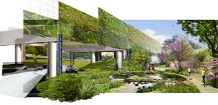
A Vision of the Girard Interchange Connection
The space beneath Interstate 95 at the newly designed Girard Avenue Interchange is imagined as an extension of the greenway to connect Penn Treaty Park and Richmond Street. Stormwater from the highway is filtered down into the park to reduce runoff. Planted sound walls mitigate both noise and air pollution. Innovative lighting beneath the structure creates a safer, more traversable portal between the riverfront and the surrounding neighborhoods. The spaces beneath the elevated structure may also be developed into recreational areas such as skate parks, as shown.